3D Sensing from the Farm to the Sky: Lidar Applications Beyond Automobiles
Lidar (Light Detection and Ranging) technology has become commonplace in automobiles over the last decade. First developed in the 1960s and used by Apollo astronauts to map the surface of the moon, this versatile technology is now gaining wide application. Just walking along the street in any modern city you may even be encountering lidar every few yards.
How Does Lidar Work?
Lidar, or Light Detection and Ranging, is sensing technology that uses pulsed laser light to measure distance. Current state-of-the art lidar systems typically use pulses of light at 905 nanometers (nm) or 1550 nm – in the near-infrared range of the electromagnetic spectrum, which is invisible to the human eye.
Both 905 and 1550 wavelengths provide the same distance-sensing capability (hundreds of meters under ideal conditions). However, light pulses at 1550 nm can be affected by water (bodies of water or even just rain) with significant signal degradation. Thus, many automakers and other users are now focusing on 905 nm for lidar sensing applications where moisture is likely to be present in the environment.1 The 905 nm wavelengths also require less energy to produce, an important factor when considering all of the battery/power demands of automobile operations.
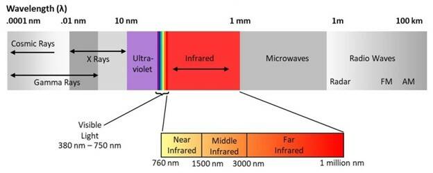
The electromagnetic spectrum, including visible light (380 nm – 750 nm) and near-infrared, which incudes the common lidar frequencies of 905 nm and 1550 nm. (Image Source: AZO Optics)
A lidar system measures the time it takes for reflections of near-IR light pulses to bounce back (called the “time of flight” or TOF) from objects or landscapes. “The waveform that returns to the sensor may be recorded in two ways. A discrete return records individual points for the peaks in the waveform. This system may record between one and four returns from each laser pulse. A full waveform is more complex and will capture more information.”2 System algorithms then use all the TOF data to create a very accurate 3D map of an object or environment.

Lidar systems measure the time it takes for reflected near-IR light pulses to be received by a sensor (TOF) and use this data to calculate distances and construct a 3D map of an object or the environment.
Applications of Lidar
Adoption of lidar technology in the automotive industry is already significant, growing at more than 30% CAGR to 2027.3 Vehicle makers use lidar sensors for various advanced driver assistance systems (ADAS), and for self-driving cars at various levels of autonomy.
Lidar adoption outside the automotive industry is also continuing to grow. While automotive uses (autonomous vehicles and ADAS) will still dominate the lidar market—projected to reach $7 billion by 20274—non-automotive applications such as mapping and meteorology are all on a growth trajectory. From farms to smart cities, from space to the bottom of the ocean floor, there are a wealth of use cases for the technology:
- Smart Cities – Lidar can be used for traffic monitoring, helping cities better understand the volume and patterns of traffic and thus coordinate traffic signals to reduce congestion. Likewise, the French government has been implementing a 3D lidar system for highway speed monitoring and enforcement. Lidar can also track pedestrian traffic patterns for better urban planning. Law enforcement agencies and private property owners are also finding lidar useful for security monitoring.
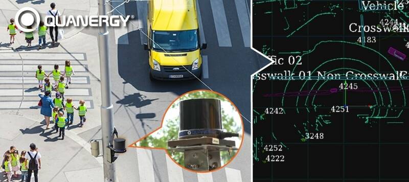
Seoul, South Korea improved the safety of school zones using a smart lidar solution from Quanergy & iCent. (Image Source).
- Scientific Exploration – Airborne lidar systems on drones or low-flying planes are enabling scientists to map large swaths of the planet in precise detail for geologic and environmental data. Airborne lidar images taken across large landscape areas can now offer resolution down to the level of each single meter of the earth’s surface. Lidar can even penetrate dense tree canopies to identify structures on the ground. This detailed topographic data is helping archeologists discover ancient structures that had been previously unnoticed, including vast Mayan temple ruins in Mexico and early Colonial settlements in New England.
- Space – At the same time, NASA is continuing its use of lidar technology for planetary mapping, only now to explore the surface of Mars. They have even been able detect snow falling in the Mars atmosphere. A different type of lidar, called bathymetric lidar, uses blue-green wavelengths to that can penetrate bodies of water for applications such as coastal mapping.
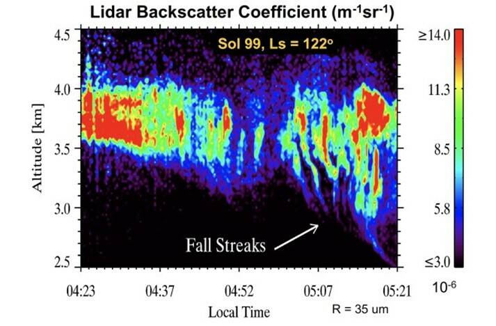
Lidar images captured the streaks of tiny ice crystals in Martian clouds just like those we see for earthly snow. (Image: Source)
- Weather & Climate – Lidar pulses can be used to measure more than just cars, people and landscapes, their short wavelengths can also detect tiny objects such as particles and aerosols in the air. Multiple types of lidar are used by meteorologists and climatologists to study cloud patterns and atmospheric changes. Meanwhile, botanists use lidar data to track changes in forestation and glaciers in regions around the globe.
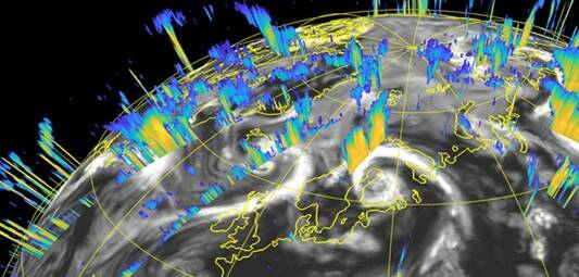
Combining radar data with lidar data improves the accuracy of weather and storm forecasts. (Image: Source)
- Energy – New technology called Differential Absorption LiDAR (DIAL), detects trace amounts of gas molecules in the air that indicate the location of underground oil and gas deposits. Lidar systems can also calculate wind speed and direction, helping wind farms to find the best locations for turbines.
- Agriculture – Lidar is being used to create detailed, 3D models of agricultural landscapes that provide highly accurate information to help farmers. Identifying water flow and drainage can improve irrigation and mitigate soil erosion. Sun exposure and soil composition data improves planting plans. Lidar images can even be used to characterize micro crop zones by plant structure, height, density, and homogeneity. Similarly, forestry management can benefit from the same detailed landscape and vegetation analysis.
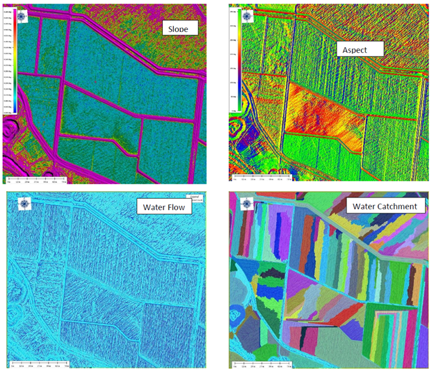
Lidar mapping data can be used for multiple types of agricultural analyses, such as drainage and plant growth. (Image Source)
- Augmented Reality – Augmented reality systems combine digital images generated by an application with a view of the user’s real-world environment. The environment has typically been incorporated via camera integrated with the AR images. With the new Apple iPad Pro, lidar has now been added to a consumer electronic device as the first step in developing completely 3D AR experiences.
Measuring Lidar Emitters
The accuracy and reliability of lidar imaging depends on the quality of the NIR 3D sensing equipment and systems used. The emission wavelength needs to be correct for the application, laser pulses and patterns need to be precise, and emission strength needs be sufficient for the sensing distance but not overly powered such that energy is wasted or that it becomes harmful. Metrology instruments can characterize the performance of NIR lasers for TOF and other applications such as structured light or dot patterns. Radiant’s NIR Intensity Lens solution can be used to measure NIR lasers and LEDs to ensure the performance and accuracy of 3D sensing systems used for:
- Facial identification and gesture recognition
- Eye tracking and iris detection
- Lidar for autonomous vehicles, drones, robots, etc.
- Foveated rendering and gaze-directed UI for XR (extended reality) devices
- Presence, position, and gaze tracking for in-vehicle driver and occupant monitoring systems (DMS and OMS)
- Optimization of virtual images for AR head-up displays (AR HUD)
- Simultaneous localization and mapping (SLAM)
- Other near-infrared 3D sensing applications
Using Fourier optics, the NIR Intensity Lens captures the complete angular distribution of an NIR light source (to ±70 degrees) in a single image and achieves an angular resolution of up to approximately 0.05 degrees per image sensor pixel. Paired with the ProMetric® Y16 Imaging Radiometer featuring a 16-megapixel image sensor, the NIR Intensity Lens has the capability to measure radiant intensity, power, and radiant flux with a high degree of accuracy at each view angle.
Used with our TT-NIRI™ software, this solution helps manufacturers of 3D sensing systems to ensure accurate distribution and intensity of NIR emissions for object and area sensing, and safe levels of NIR output for use in human-machine interface applications such as eye and facial detection.
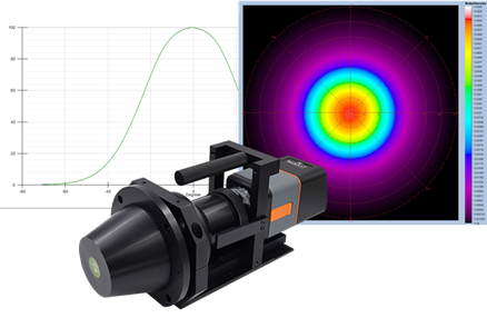
Radiant’s NIR Intensity Lens solution includes a ProMetric Imaging Radiometer, integrated Fourier optic lens, and the TT-NIRI software for accurate measurement of NIR light sources.
CITATIONS
- A Guide to Lidar Wavelengths for Autonomous Vehicles and Driver Assistance, Velodyne Lidar, November 6, 2016 and updated March 26, 2021. (Accessed October 13, 2021)
- George, N., “11 Interesting LiDAR Applications.” Cloudfactory, October 21, 2020.
- “Automotive LiDAR Market Growth Sturdy at 30.4% CAGR to Outstrip $4,348.09 Million by 2027 – COVID 19 Impact and Global Analysis by TheInsightPartners.com.” Global Newswire, April 27, 2021
- LiDAR Market Size By Product (Airborne (Topographic, Bathymetric), UAV, Terrestrial (Mobile, Static), by Type…Industry Analysis, Regional Outlook, Growth Potential, Competitive Market Share & Forecast 2021-2017. Global Market Insights, July 2021.
Join Mailing List
Stay up to date on our latest products, blog content, and events.
Join our Mailing List
